


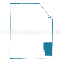
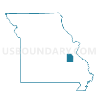
Irondale Voting District, Washington County, Missouri
About
Outline

Summary
| Unique Area Identifier | 611552 |
| Name | Irondale Voting District |
| County | Washington County |
| State | Missouri |
| Area (square miles) | 35.48 |
| Land Area (square miles) | 35.45 |
| Water Area (square miles) | 0.03 |
| % of Land Area | 99.91 |
| % of Water Area | 0.09 |
| Latitude of the Internal Point | 37.81564680 |
| Longtitude of the Internal Point | -90.68620630 |
Maps

Graphs
Select a template below for downloading or customizing gragh for Irondale Voting District, Washington County, Missouri


Neighbors
Neighoring Voting District (by Name) Neighboring Voting District on the Map
- Bismarck No. 2 Voting District, St. Francois County, MO
- Caledonia Voting District, Washington County, MO
- Frankclay Voting District, St. Francois County, MO
- Hopewell Voting District, Washington County, MO
- Ozark Heights Voting District, Washington County, MO
- Stony Point Voting District, Washington County, MO
Top 10 Neighboring County Subdivision (by Population) Neighboring County Subdivision on the Map
- Perry township, St. Francois County, MO (12,617)
- Breton township, Washington County, MO (10,326)
- Randolph township, St. Francois County, MO (10,161)
- Iron township, St. Francois County, MO (3,257)
- Concord township, Washington County, MO (2,446)
- Bellevue township, Washington County, MO (994)
Top 10 Neighboring Place (by Population) Neighboring Place on the Map
Top 10 Neighboring Unified School District (by Population) Neighboring Unified School District on the Map
- Potosi R-III School District, MO (13,408)
- West St. Francis County R-IV School District, MO (5,878)
- Bismarck R-V School District, MO (3,674)
- Valley R-VI School District, MO (2,931)
Top 10 Neighboring State Legislative District Lower Chamber (by Population) Neighboring State Legislative District Lower Chamber on the Map
- State House District 107, MO (40,428)
- State House District 110, MO (37,588)
- State House District 152, MO (34,200)
Top 10 Neighboring State Legislative District Upper Chamber (by Population) Neighboring State Legislative District Upper Chamber on the Map
Top 10 Neighboring 111th Congressional District (by Population) Neighboring 111th Congressional District on the Map
Top 10 Neighboring Census Tract (by Population) Neighboring Census Tract on the Map
- Census Tract 9504, St. Francois County, MO (6,866)
- Census Tract 4604, Washington County, MO (5,062)
- Census Tract 9501.02, St. Francois County, MO (4,765)
- Census Tract 4605, Washington County, MO (4,159)
- Census Tract 9506, St. Francois County, MO (3,336)
Top 10 Neighboring 5-Digit ZIP Code Tabulation Area (by Population) Neighboring 5-Digit ZIP Code Tabulation Area on the Map
- 63601, MO (16,656)
- 63664, MO (8,920)
- 63660, MO (4,276)
- 63624, MO (3,757)
- 63648, MO (1,628)
- 63631, MO (849)